

A Restless Earth: Hazards in Focus
Thirty-Nine Seconds: Insights from the 2026 Venezuela Earthquake
1 Chief Scientist and Chair, ALLATRA Global Research Center
Corresponding author: John Ahn, [email protected]
On June 24, 2026, two powerful seismic pulses struck northern Venezuela, separated by less than 40 seconds. The United States Geological Survey (USGS) estimated their magnitudes at 7.2 and 7.5. The ongoing debate among seismologists regarding whether these were two distinct earthquakes or a single complex rupture raises critical questions for seismic hazard assessment. Addressing these questions is essential to reevaluating current seismic hazard assessment methodologies.
Article
On the evening of June 24, 2026, at 6:04 p.m. local time (22:04 UTC), the coast of northern Venezuela was shaken by a powerful initial pulse whose moment magnitude (Mw) USGS seismologists later estimated at 7.2. Less than 40 seconds later, the ground shook again: the USGS estimated the second pulse at magnitude 7.5. The two shocks, separated by less than a minute, occurred in nearly the same area near the town of Yumare in Yaracuy State. They resulted in the country’s worst natural disaster in more than a century. Immediately after the shocks, the USGS PAGER rapid assessment system issued a red alert, indicating a high probability of very large losses [1]. The death toll rose as rubble was cleared: by mid-July, authorities had confirmed more than 5,000 deaths, over 16,700 injuries, and approximately 17,800 people left homeless [2]. UN agencies (UNDRR and UN OCHA) estimated direct damage to buildings and infrastructure at approximately $37 billion [3]. A tsunami warning was issued as far away as Puerto Rico and the U.S. Virgin Islands; the shaking was felt in Bogotá, northern Brazil, and the Dominican Republic; and the country’s main airport was closed. La Guaira State and the capital, Caracas, were hit hardest, with dozens of buildings collapsing, including multistory apartment buildings.
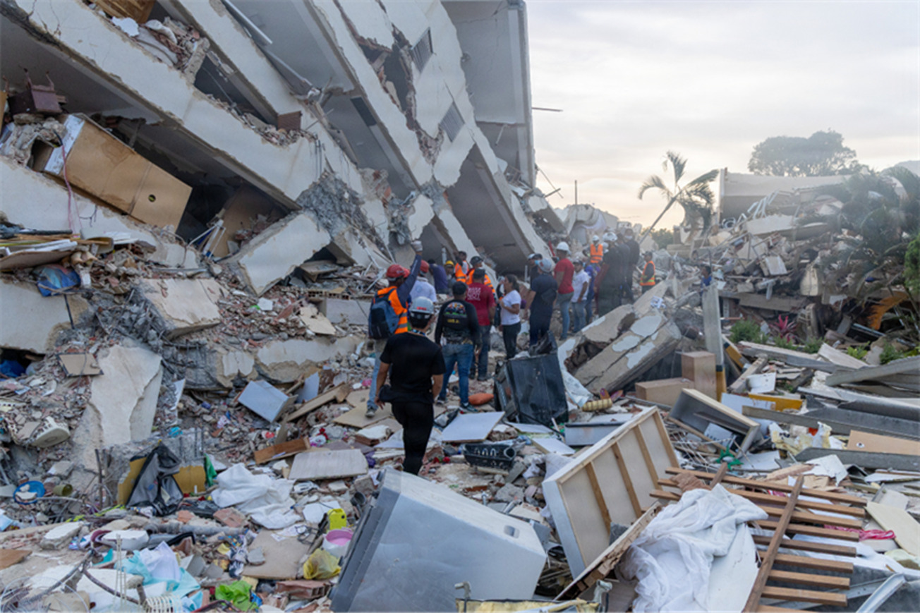
Beyond the scale of the disaster, these events became the focus of significant scientific debate. The unusual pattern of the earthquake sequence continues to challenge physical interpretation. Understanding this requires an examination of the region’s geology. Northern Venezuela is situated within a complex boundary zone between the Caribbean and South American lithospheric plates. These plates move relative to each other at approximately 18–20 millimeters per year, with deformation distributed among several major right-lateral strike-slip faults, primarily the Boconó, San Sebastián, and El Pilar faults (Fig. 1) [4, 5]. While a major earthquake in this zone is not geologically unexpected, such events are rare in the historical record. According to the British Geological Survey, only seven earthquakes of magnitude 6 or greater have occurred in the region over the past century [5]. The last event of comparable strength was the 1967 Caracas earthquake, which had a magnitude of approximately 6.6 and resulted in about 240 fatalities [5]. The mainshock of June 24, 2026, was the strongest earthquake in Venezuela since approximately 1900, making it the most powerful of the entire instrumental era [6]. However, the rarity of large earthquakes does not imply a low long-term hazard, as stress accumulates along these faults for decades before eventual release.
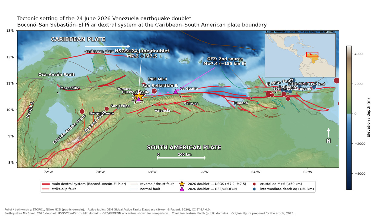
This pair of earthquakes, what seismologists call a doublet, became the focus of the scientific debate. A doublet is a descriptive term for two events of comparable magnitude that occur close together in time and space, but it is not a strict classification with a single threshold. Typically, the events in a doublet are usually separated by minutes, hours, or even days. In this case, less than 40 seconds elapsed [5].
The difference in magnitude is also telling. Båth’s law describes a statistical average: the strongest aftershock is generally about 1.2 magnitude units weaker than the mainshock. In Venezuela, the difference was only 0.3 units (M7.5 versus M7.2), an unusually small gap for a conventional mainshock-and-aftershock sequence. This alone does not prove that the sequence comprised two independent mainshocks, but it clearly departs from the typical pattern. Estimates of the source locations also diverge. The USGS places the two events relatively close together, whereas Germany's national geoscience centre (GFZ) locates the onset of the second subrupture approximately 160 kilometers farther east, closer to Caracas [4]. Until these differences are reconciled, it is premature to conclude that the rupture zones overlap almost completely. The historical parallel is likewise tentative but revealing. Modern researchers reconstruct the events of March 26, 1812, which destroyed Caracas, as two subevents: an approximately M7.4 earthquake on the Boconó fault in the Barquisimeto–San Felipe area, followed tens of minutes later by an approximately M7.1 earthquake on the San Sebastián fault closer to the capital [7]. This demonstrates the region’s capacity for cascading ruptures, although it does not establish doublets as a signature feature of any particular fault.
|
Parameter
|
Event 1
|
Event 2
|
|---|---|---|
|
Magnitude (USGS) [1]
|
7.2
|
7.5
|
|
Magnitude (GFZ) [4]
|
7.3
|
7.4
|
|
Time (UTC)
|
22:04:33
|
22:05:12
|
|
Interval
|
—
|
39 seconds
|
|
Depth
|
21.9 km
|
10.0 km
|
|
Mechanism
|
right-lateral strike-slip
|
right-lateral strike-slip
|
This raises a central question: were these two earthquakes or a single complex rupture? Rupture during an M7.2 event lasts approximately 30 seconds, so the first rupture might still have been underway when the second shock began less than 40 seconds later. The USGS maintains two separate catalog events and retrospectively identifies the first as a foreshock and the second as the mainshock [8]. The GFZ emphasizes [4] that this division is useful for cataloging purposes, but the sequence may physically have represented a nearly continuous rupture consisting of two subevents.
The European centers INGV (Italy's National Geophysics Institute) and GEOSCOPE (French global seismic network) also favored interpreting the sequence as a single complex rupture of magnitude 7.6–7.8. Similarly, the Global Centroid Moment Tensor (GCMT) catalog recorded the Venezuela doublet as a single event (Mw 7.52). Because the signals overlapped, different agencies obtained substantially different estimates of magnitude and location. Karen Lythgoe, a research fellow at the University of Edinburgh, explicitly considers it possible that this was a single complex event of magnitude 7.6–7.7 rather than two separate events [5]. Seismologist Judith Hubbard of Cornell University is more cautious: a final determination requires “more scientific data” [9].
Several researchers have focused on the physics of the second shock’s almost instantaneous triggering. The most likely general explanation is stress redistribution: slip on the first segment altered the stress state of neighboring segments, and if one was already close to failure, the additional stress change may have been sufficient to initiate the second rupture. Given the extremely short interval, two mechanisms may have operated simultaneously: static Coulomb stress transfer to a neighboring fault and dynamic triggering by passing seismic waves [5]. As Mark Quigley of the University of Melbourne notes, those waves could have “shaken loose” a neighboring segment already under stress [10]. Harold Tobin, director of the Pacific Northwest Seismic Network at the University of Washington, also considers it highly likely that the first earthquake triggered the second [11]. Without a detailed rupture model, however, the sequence cannot yet be attributed to any single mechanism; these remain working hypotheses.
The overlap of two nearly simultaneous ruptures also complicated real-time analysis. The signals from the two subevents became superimposed, different centers obtained different estimates of magnitude and location, and automated systems initially overestimated the magnitude. Disentangling the two sources ultimately required manual and model-based analysis [4, 11]. Preliminary data indicate that the rupture propagated eastward toward Caracas, concentrating energy in that direction. This rupture-directivity effect probably amplified ground motion toward the capital, although it was not the only cause of the destruction.
Rupture directivity also helps explain one of the disaster’s most notable paradoxes: La Guaira, approximately 170 kilometers from the epicenter, experienced more severe damage than Barquisimeto, which is only about 100 kilometers away. The epicenter marks only the initiation point of a rupture. More significant factors include the distance to the entire rupture plane, the direction of rupture propagation, local ground conditions, and building vulnerability. Barquisimeto is located opposite the direction of rupture propagation and is built on hard rock; the observed effects there corresponded to moderate macroseismic intensity levels V–VI on the Mercalli scale.
The Mercalli Scale
The Modified Mercalli Intensity Scale (MMI), developed in 1931 from Giuseppe Mercalli’s original 1902 scale, measures macroseismic intensity, meaning the observed effects of an earthquake at a particular location on Earth’s surface. This differs from magnitude, which characterizes the energy released during the earthquake.
The scale comprises 12 intensity levels, from I to XII:
· I–III: Shaking is not felt or is barely perceptible; only a few observers detect it, primarily on the upper floors of buildings.
· IV–V: Weak shaking is felt by most of the population; furniture and dishes typically vibrate.
· VI–VII: Moderate intensity may compromise structural integrity; masonry can crack and plaster can flake.
· VIII: Significant damage and partial collapse of buildings with low load-bearing capacity.
· IX–X: Severe destruction, including deformation of soil and rock masses.
· XI–XII: Complete destruction of infrastructure, with seismic waves visible at the surface.
Source: USGS Earthquake Hazards Program, Modified Mercalli Intensity Scale
Caracas, despite its greater distance, was situated in the path of eastward rupture directivity, and the soft sedimentary deposits in its valley amplified shaking at certain frequencies. Intensity in Caracas is estimated at level VIII. La Guaira was both near the eastern part of the rupture zone and characterized by particularly vulnerable construction; the observed destruction corresponds to intensity levels IX–X [5]. Mercalli intensity measures observed effects and damage, rather than the energy released by an earthquake. Extreme structural vulnerability exacerbated the physical effects: older buildings constructed under outdated codes, informal housing lacking engineering oversight, and soft-story ground floors used for parking. The combination of rupture directivity, soft soils, and fragile structures ultimately determined the scale of the tragedy.
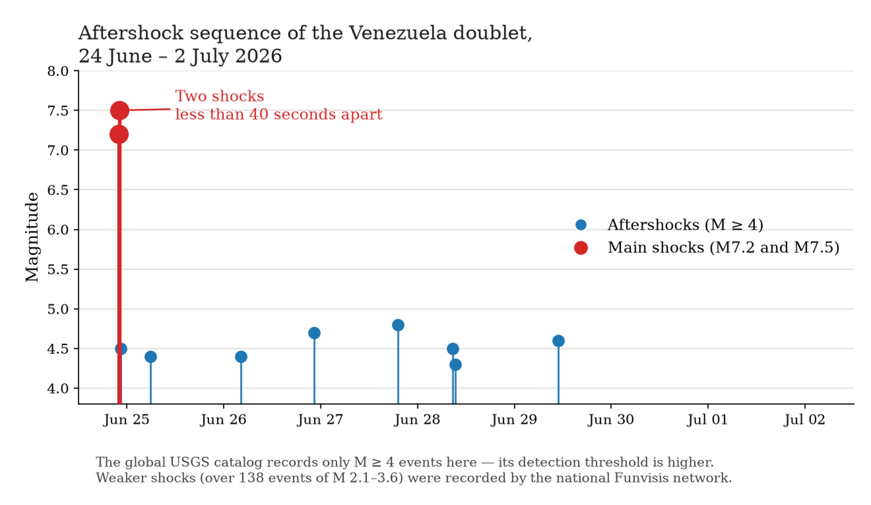
The sequence had another unusual feature: what did not happen. During the first day, global catalogs showed unusually few moderate aftershocks. By June 26, the German GFZ center had recorded only one event above magnitude 4, although several would normally be expected after an event above magnitude 7 [4]. This was an early observation, not a definitive conclusion that there was an “aftershock deficit.” The denser national network Funvisis (Venezuela's national seismological service) recorded many smaller events, more than 138 earthquakes of magnitude 2.1–3.6 by the same date, that global networks may simply have been unable to locate because of their higher detection thresholds [4]. During the first week, the global USGS catalog contained only eight aftershocks of magnitude 4 or greater within a radius of approximately 250 kilometers (Fig. 2), and only three within 100 kilometers of the source. Even moderate aftershocks remained dangerous: they could collapse already damaged buildings, dislodge rubble, and trigger landslides.
These specific anomalies point to a broader, more sobering conclusion. The Venezuela sequence demonstrates that earthquakes can cascade from one fault to another, while, as paleoseismologist Chris Goldfinger of Oregon State University notes, seismic hazard models often consider rupture scenarios involving only a single segment [12]. A classic example of a multifault event is the 2016 Kaikōura earthquake in New Zealand (M7.8). Hamling and colleagues report that the rupture propagated along at least 12 faults over more than 170 kilometers, making it one of the most complex ruptures ever recorded [13]. Contemporary models are beginning to incorporate such cascades. It is therefore more accurate to state that some regional assessments may underestimate the probability and maximum scale of multifault events, rather than exclude them entirely. The Venezuelan case raises a specific question: Has the potential linkage among the Boconó, San Sebastián, and El Pilar faults been adequately considered?
The story also has a global context that has generated considerable speculation. The Venezuela doublet occurred over several days, during which a series of notable earthquakes struck around the world. The sequence began nearly seven hours before the Venezuela event: at 15:10 UTC on June 24, an M5.6 earthquake struck Northern California near Redwood Valley. It was the region’s strongest earthquake in decades, but caused no serious damage [1]. The Venezuela doublet followed. Just 26 minutes later, at 22:30 UTC, an earthquake struck off Japan’s Iwate Prefecture. The USGS estimated its magnitude at Mw 6.9 [14], while the Japan Meteorological Agency (JMA) assigned it Mj 7.2. These are different magnitude estimates produced by different agencies and methods. Two days later, on June 26, an M6.5 earthquake struck near Sarangani, Philippines. On June 27, a deep M6.1 earthquake at approximately 200 km depth struck the Hindu Kush Mountains of northern Afghanistan and was felt in Kabul and across much of Pakistan [15] (Fig. 3).
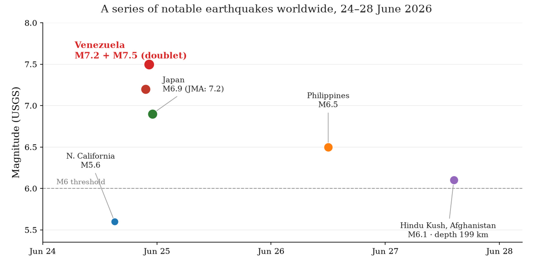
On June 24 alone, three earthquakes of approximately magnitude 7 or greater occurred worldwide, and social media users immediately began discussing a supposed global “awakening” of Earth. But the actual record lets us be precise. Since 1964, the global USGS catalog has never recorded a single day with more than three earthquakes of magnitude 6.9 or greater—and even three earthquakes of this magnitude in a single day have occurred only nine times in more than sixty years. June 24, 2026, marked the ninth such occurrence (Fig. 4).
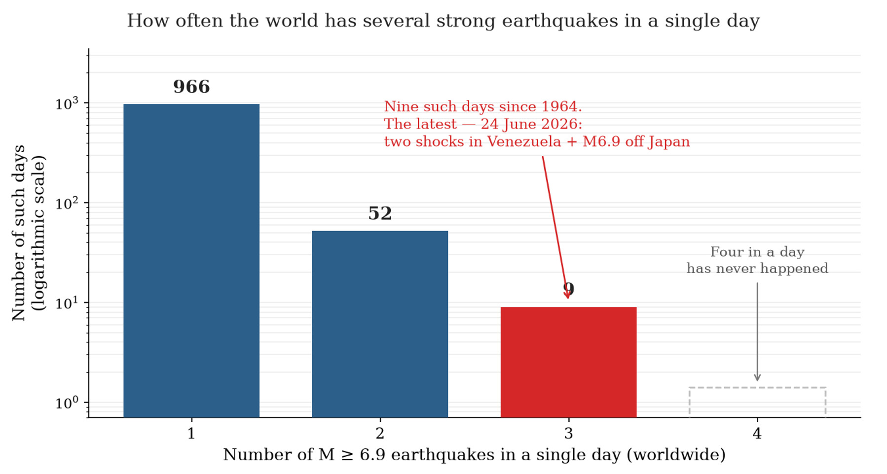
What distinguishes June 24, 2026, is that these three earthquakes above magnitude 6.9 were not part of a single aftershock cascade. Two of them were the Venezuela doublet; the third struck off Japan 26 minutes later, on a different plate boundary thousands of kilometers away (Fig. 5).
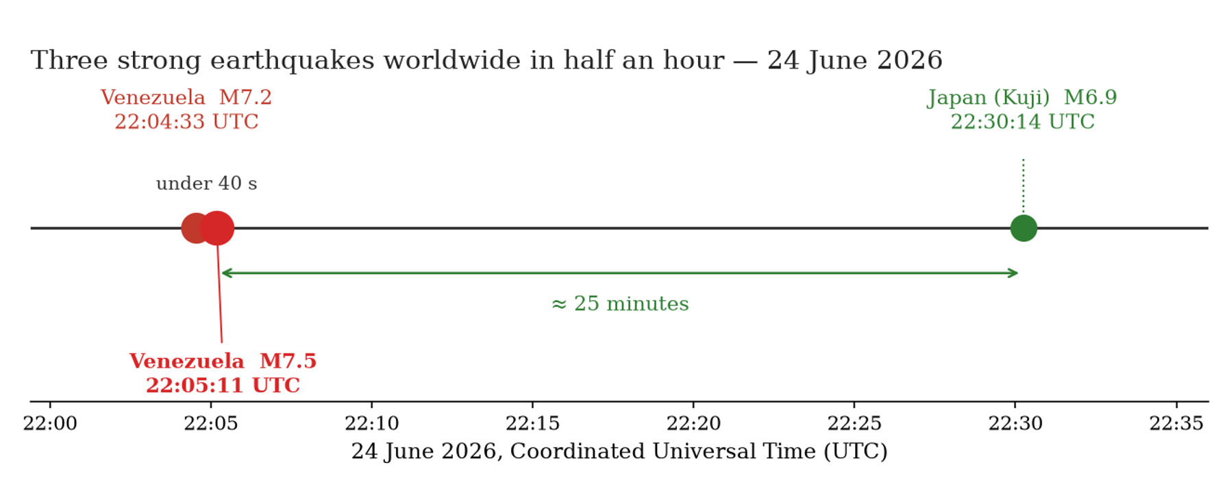
The more important point is that this was a statistical rarity, not evidence of a common physical process. William Barnhart of the USGS Earthquake Hazards Program described the near-simultaneous earthquakes in California, Japan, and Venezuela as a random coincidence [14, 16]. According to Martin Hudson of the University of California, Los Angeles, a century of observations has not established any causal connection between earthquakes separated by such great distances [16].
The distinction between the two mechanisms is fundamental. Static Coulomb stress changes decay rapidly with distance and are significant only near a rupture, whereas surface waves can, in theory, trigger distant earthquakes dynamically. Temporal coincidence alone, however, does not demonstrate such triggering. Judith Hubbard of Cornell University noted that surface waves from the M7.5 Venezuela earthquake could have physically reached Japan before the Japanese earthquake began, making this scenario theoretically possible. She emphasized, however, that the Iwate region was already under elevated stress following an M7.5 earthquake in December 2025, and the Japanese M6.9 event fits logically within its own regional sequence [8, 9].
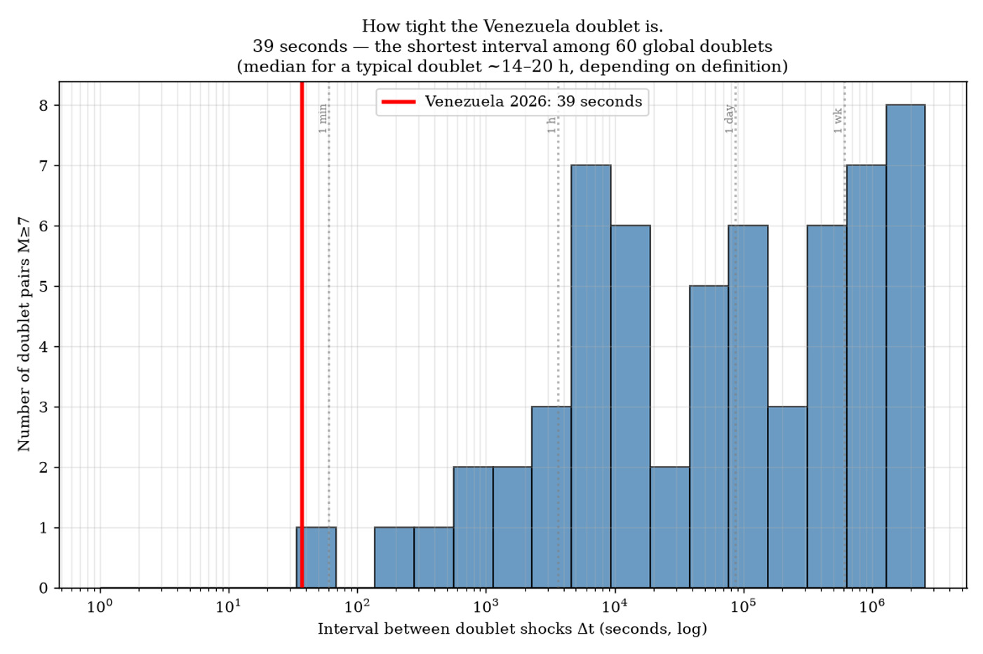
The exceptional nature of the Venezuela doublet becomes clear only when it is compared with global statistics. By three independent measures, it lies near the extremes of the relevant distributions. The first measure is temporal proximity. We compiled a catalog of 60 doublets of magnitude 7 or greater from 1970 through 2026, selecting pairs with a magnitude difference of no more than 1.0, a separation of less than 150 kilometers, and an interval of less than 30 days. Against this background, the Venezuelan shocks, separated by less than 40 seconds, have the shortest interval in the entire sample. The next-shortest case, recorded near the South Sandwich Islands, had an interval of 2.4 minutes, four times longer. Earthquakes in a typical M7+ doublet are separated by hours. Depending on how a doublet is defined, the median interval is approximately half a day (about 14–20 hours). Venezuela’s 39-second interval is thousands of times shorter (Fig. 6).
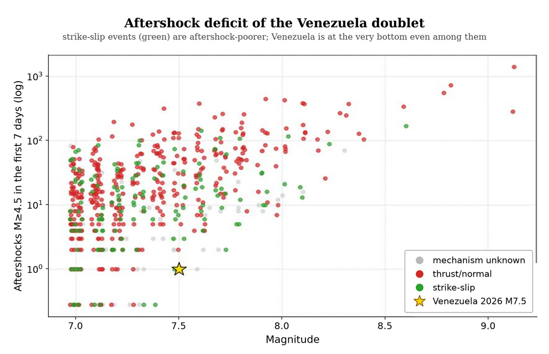
The second measure is the unusual quiet that followed the mainshocks. A major earthquake is usually followed by a swarm of aftershocks; sequences that produce more aftershocks are considered more “productive.” To compare events consistently, seismologists apply a common criterion: the number of aftershocks of magnitude 4.5 or greater that occur during the first week within a spatial window approximately one rupture length across. The Venezuela pair produced only one such earthquake, an exceptionally low number. Among comparable strike-slip earthquakes of magnitude 7.2–7.8, most produce far more aftershocks, averaging approximately 14. Thrust earthquakes average approximately 29. Venezuela ranks near the bottom of this distribution: only about one-fifth of comparable events (approximately 18–22%) produce as few aftershocks or fewer (Fig. 7). Some of this quiet can be explained. During the first hours, the national station network operated intermittently, and strike-slip ruptures generally produce fewer aftershocks. Even so, an observational gap alone cannot explain the complete absence of earthquakes of magnitude 4 or greater near the rupture zone during the first day after an M7.5 event.
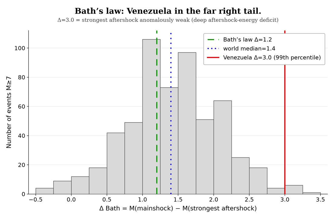
The third measure is the unusually large magnitude gap between the mainshock and its strongest aftershock. Seismologists use a simple empirical rule, Båth’s law: the strongest aftershock is usually about 1.2 magnitude units weaker than the mainshock. For Venezuela, if the second mainshock is excluded and the strongest of the smaller subsequent events (M4.5) is used, the gap is 3.0. In other words, the strongest aftershock was not merely weaker than usual but anomalously weak. Such a large gap is extremely rare: among earthquakes of magnitude 7 or greater, only about 1% have a value this large or larger (Fig. 8). Taken together, the three measures indicate that the Venezuela sequence behaved not like a conventional mainshock-and-aftershock sequence, but like two nearly equal primary shocks followed by almost no conventional aftershock sequence.
Ultimately, the most sobering lesson of the Venezuela disaster lies not in tectonics but in human vulnerability. Strong ground motion became catastrophic where high population density, old or structurally weak buildings, unstable soils, and limited response capacity coincided. It would be inaccurate to describe the country as entirely “scientifically blind”: the Funvisis network continued to record earthquakes and provided a more detailed local catalog. Questions remained, however, about the condition of some equipment, the accessibility of data, and the speed of public alerts. A significant portion of the housing stock was constructed before earthquake-resistant building practices became standard, while the recent economic crisis limited inspections and retrofitting of older buildings. As Goldfinger notes, many buildings around the world were constructed before modern plate tectonics was understood, and retrofitting the building stock of entire cities for seismic resilience remains an extraordinarily difficult task [12].
The official address to the nation came more than two hours after the earthquakes. Timely public communication was hindered by a disrupted communications infrastructure and the closure of hundreds of local media outlets in the preceding years. Moreover, buildings had been designed for expected ground-motion parameters, while a shallow earthquake with a rupture directed toward the capital exceeded the design basis of a significant portion of the building stock.
The primary conclusion from the 39 seconds on June 24 is the significant impact of vulnerability. This disaster offers insights with relevance beyond national boundaries. As observed in Venezuela, the Earth does not always release accumulated stress through a single, discrete shock; instead, stress may be released through an interconnected cascade of ruptures that is difficult to classify in real time and does not conform to conventional hazard models. While seismologists continue to debate whether this was one event or two, the mechanism that triggered the second shock, and the scarcity of moderate aftershocks, the practical implications remain unchanged.
Seismic risk maps should incorporate scenarios in which rupture propagates from one segment to another and from one fault to another. The maintenance and density of monitoring networks, as well as the open availability of their data, are essential. Buildings in seismically hazardous areas should be designed and retrofitted to withstand earthquakes that have not occurred in recent history. Although science cannot yet predict the exact time, location, or magnitude of an earthquake, it is increasingly capable of explaining where and why cities collapse. This understanding provides the most effective means of reducing the toll of future disasters, whose countdown is always measured in seconds.
About the authors


References
- U.S. Geological Survey, Earthquake Hazards Program. ANSS Comprehensive Earthquake Catalog (ComCat). Accessed July 2, 2026. https://earthquake.usgs.gov/data/comcat/
- Al Jazeera. “Venezuela Quake Death Toll Tops 5,000 as IMF Releases Emergency Aid.” July 18, 2026. https://www.aljazeera.com/news/2026/7/18/venezuela-quake-death-toll-tops-5000-as-imf-releases-emergency-aid
- UN News. “Venezuela Quake: UN Continues to Scale Up as Damage Estimate Reaches $37 Billion.” July 7, 2026. https://news.un.org/en/story/2026/07/1167879
- GFZ German Research Centre for Geosciences. “Severe Earthquake in Venezuela: GFZ Information, Status Report.” June 26, 2026. https://www.gfz.de/en/press/news/details/severe-earthquake-in-venezuela-gfz-information-status-report
- Science Media Centre. “Expert Reaction to Earthquake in Venezuela.” June 25, 2026. https://www.sciencemediacentre.org/expert-reaction-to-earthquake-in-venezuela/
- Encyclopædia Britannica. “Venezuelan Earthquakes of 2026.” July 18, 2026. https://www.britannica.com/event/Venezuelan-earthquakes-of-2026
- Chaves E. J., Stein R. S., Toda S. “Venezuela’s Doublet Leaned Toward Caracas.” Temblor, June 30, 2026. https://temblor.net/earthquake-insights/venezuelas-doublet-leaned-toward-caracas-17281
- Hubbard J. A., Bradley K. “Catastrophic M7.5 Earthquake Strikes Northern Venezuela.” Earthquake Insights, June 25, 2026. https://earthquakeinsights.substack.com/p/catastrophic-m75-earthquake-strikes
- Martin M. “The Science Behind the Back-to-Back Earthquakes That Struck Northern Venezuela.” NPR, June 25, 2026. https://www.npr.org/2026/06/25/nx-s1-5869928/the-science-behind-the-back-to-back-earthquakes-that-struck-northern-venezuela
- Quigley M. “Was Venezuela Struck by an Earthquake ‘Doublet’? Here’s What We Know So Far.” The Conversation, June 25, 2026. https://theconversation.com/was-venezuela-struck-by-an-earthquake-doublet-heres-what-we-know-so-far-286136
- Maturana J. “Seismic Doublet: The Phenomenon That Turned Venezuela’s Tragedy into Catastrophe.” Euronews, June 26, 2026. https://www.euronews.com/2026/06/26/seismic-doublet-the-phenomenon-that-turned-venezuelas-tragedy-into-catastrophe
- Riddle K. “What Made the Deadly Venezuelan Earthquakes Different.” NPR, June 25, 2026. https://www.npr.org/2026/06/25/nx-s1-5870557/what-made-the-deadly-venezuelan-earthquakes-different
- Hamling I. J., Hreinsdóttir S., Clark K., et al. “Complex Multifault Rupture during the 2016 Mw 7.8 Kaikōura Earthquake, New Zealand.” Science 356 (2017): eaam7194. https://doi.org/10.1126/science.aam7194
- Lapointe E. “World Rocked by 4 Powerful Earthquakes in Less Than 8 Hours. Were They Connected?” Gizmodo, June 25, 2026. https://gizmodo.com/world-rocked-by-4-powerful-earthquakes-in-less-than-8-hours-were-they-connected-2000777615
- Reuters. “Strong Earthquake Hits Hindu Kush, Shaking Afghanistan and Pakistan.” U.S. News & World Report, June 27, 2026. https://www.usnews.com/news/world/articles/2026-06-27/strong-earthquake-hits-hindu-kush-shaking-afghanistan-and-pakistan
- Ede-Osifo U. “Experts Say Three Recent Powerful Earthquakes Are Not Related.” The Guardian, June 26, 2026. https://www.theguardian.com/world/2026/jun/25/three-recent-powerful-earthquakes-not-related
© 2026 John Ahn, Andrea Lešková. This article is published under a Creative Commons Attribution 4.0 International licence (CC BY 4.0) unless a different licence is stated in the credit line of an individual item. The authors retain copyright; ALLATRA Natural Science Review holds the right of first publication. The Review charges no submission, publication, or article processing fees. © 2026 ALLATRA Inc.